Former Rock Nook Mill and Surrounding Land
Welcome to the Former Rock Nook Mill Consultation Website.
About Former Rock Nook Mill
Gay O’Gara Properties Ltd invites you to provide feedback on the emerging residential development proposals for the Former Rock Nook Mill site and surrounding land.
The site is located along the Rochdale Canal, running parallel with the railway line to Manchester/Leeds, and the A6033 which links Rochdale with Todmorden and West Yorkshire. The proposal is split into four development parcels, each proposed for much needed housing, with an additional site for public open space. A description of the location and proposed development for each area is set out below. Each parcel is also shown on the site location plan.
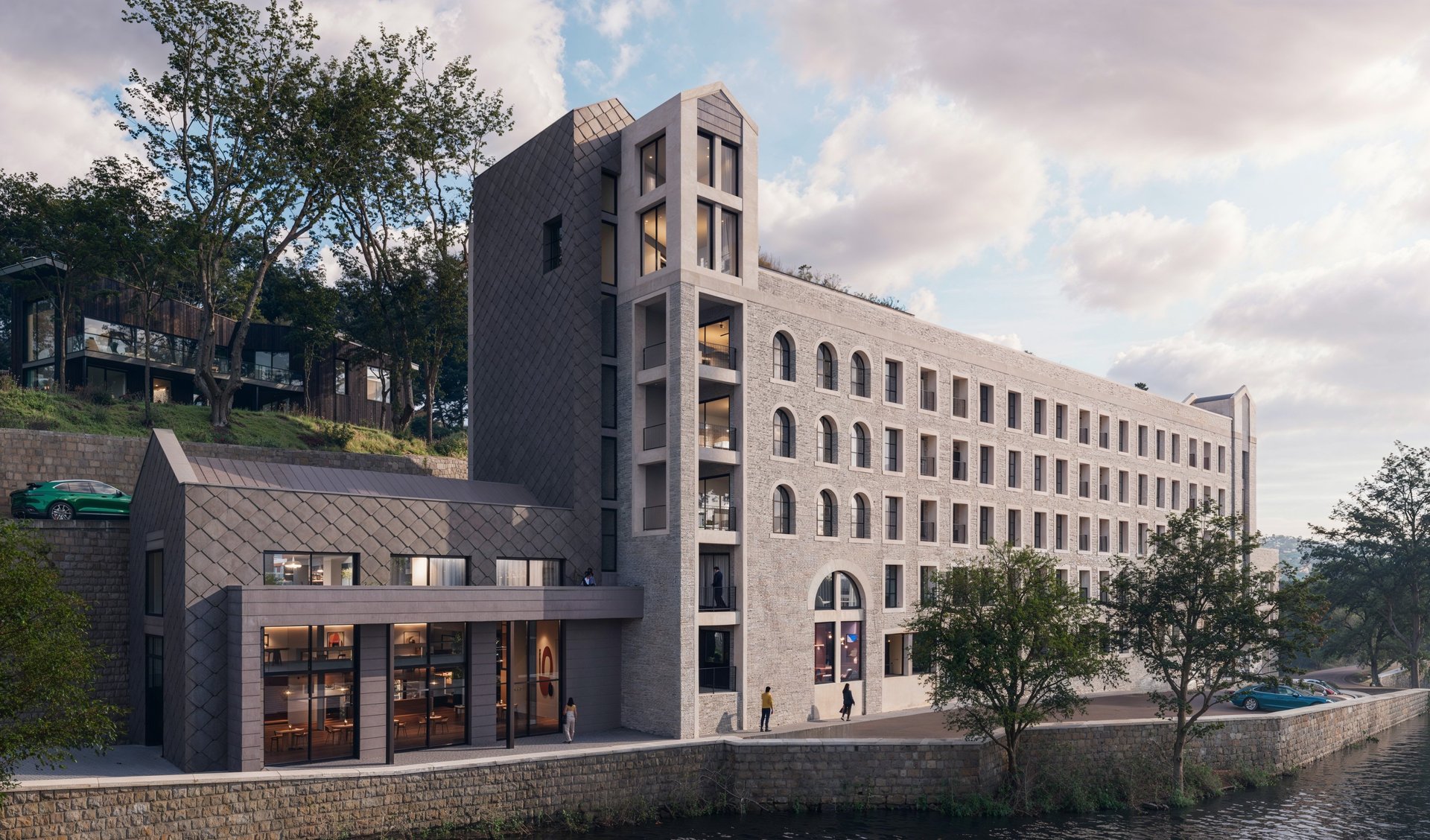
Rock Nook Mill is set within a distinctive and attractive landscape, where the site responds sensitively to its natural surroundings and the character of the wider valley setting. This includes a sympathetic design to the Rock Nook Conservation Area which the site falls entirely within.
The development benefits from its close relationship with the Rochdale Canal, with established and enhanced canal-side walks providing valuable opportunities for recreation, connectivity and wellbeing, while reinforcing the site’s integration with the local environment. There are numerous benefits of the scheme outlined on the benefit tab of this website, such as the delivery of 94 high quality family homes, a new landmark building which reflects the scale and massing of the former Mill and high-quality landscaping and amenity space.

Site location plan
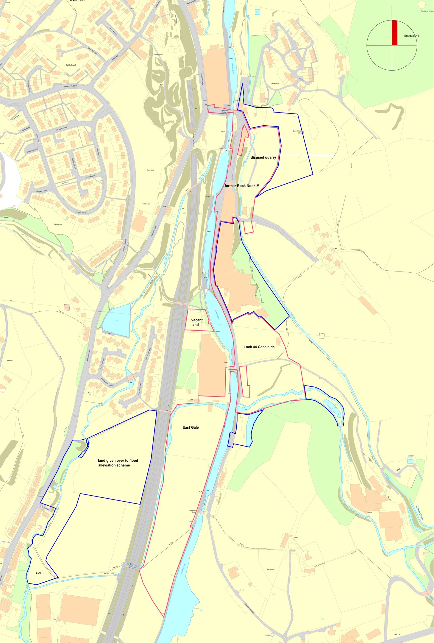
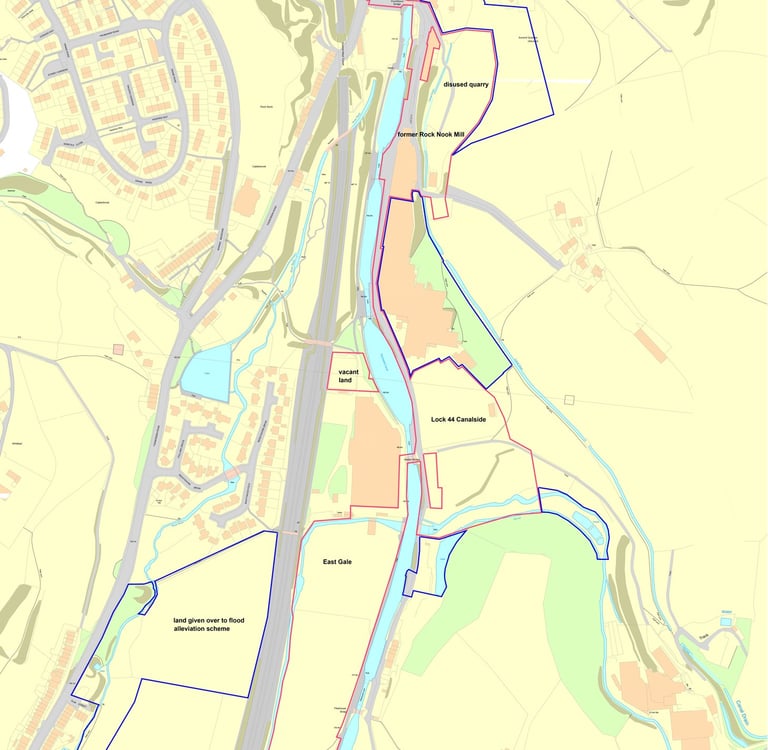
Area 1 – Former Rock Nook Mill
This area is the site of the former 5 storey Rock Nook Mill (originally built in 1886). The site is located on Lightowlers Lane adjacent to the Rochdale canal, situated between the two existing Fothergill Engineering Fabrics Mills to the north and south. The mill had been subject to significant fire damage and in August 2023 following the collapse of part of the mill, the building was deemed to be in a very dangerous condition and to pose a significant safety risk by Rochdale Council. As a result, the mill unfortunately had to be demolished. The site is currently partly cleared. Land to the rear of the mill slopes significantly.
Area 2– Disused Quarry
This area is an elevated disused car park and vacant land to the northeast of the former Rock Nook Mill. The site forms part of the former Summit Quarries which was closed in 1928. At this location the site sits higher than the site of the former Rock Nook Mill, however the land itself is generally flat with the land immediately to the east sloping steeply towards the former quarry face. To the north of the site are existing dwellings located on Timbercliffe.
Area 3 - Lock 44 Canalside
This area is located to the south of the most southerly Fothergill Engineering Fabrics Mill on the eastern side of the canal. The area is currently a vacant plot of flat land covered with grass. To the north the site is bordered by existing trees, further north are existing agricultural fields and a scrap/storage yard.
Area 4 – East Gale
This area is located to the south of Greenvale Mill and to the west of the existing canal. This site comprises a long strip of land bordered by the canal to the east and the railway line to the west. The site is currently vacant land accessed via a bridge over the canal. Part of this site will be used by the Environment Agency to construct part of the ‘Rochdale and Littleborough Flood Risk Management Scheme – Littleborough Phase 1’ which already benefits from planning permission and will assimilate into the proposed residential layout. Please refer to the below for details on the wider flood alleviation scheme
Area 5 – Potential Bowling Green/Public Open Space
This site is existing vacant land, located to the north of Greenvale Mill and adjacent to the canal. The area will provide a meaningful space to the overall amenity provision on the site for use by existing and future residents.
Other – Land Given Over to flood alleviation Scheme
This area is located to the west of East Gale, on the opposite side of the railway line. This area forms a component of the ‘Rochdale and Littleborough Flood Risk Management Scheme – Littleborough Phase 1’. This area does not form part of the planning application but is under the ownership of the applicant. This land has been given over to the Environment Agency for flood alleviation works to defend the wider Littleborough area from flooding including the proposal sites. These works have been granted planning permission and works have begun on site. Please note these works span this parcel of land and part of the ‘East Gale’ site.
We are now preparing to submit a detailed planning application which will seek permission for residential development at the site. The current development focuses on the erection of an apartment block on the site of the former Rock Nook Mill. The apartment block will create 38No spacious 1, 2 and 3 bed apartments, a community room, a resident’s room and under croft parking with 37 parking spaces. The proposed scheme seeks to provide a building on the site which reflects and respects the former Mill in terms of scale, massing and its important function as an anchor of the conservation area which bears its name.
The proposals also include supporting residential development which represents enabling works for the apartment block, including: 4 escarpment houses, 19 detached dwellings and 33 terraced properties on surrounding land. The proposal will also include a central area of open space.
Please view the proposal tab for more details.
Location
Todmorden Rd, Littleborough OL19 9EW
© 2026. All rights reserved.